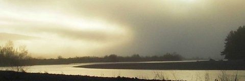
I was up on campus this evening – I walked outside to the warm glow of a spectacular apricot-hued sky. Layers of clouds were each catching the last rays of the sun painting watercolor stripes across the western sky. I wish I woulda had my camera but wouldn’t have captured the scale of it. The ingredients were perfect. An approaching storm is fizzling out – sending broken layers of clouds towards the coast. The afternoon forecast discussion reads as follows:
AREA FORECAST DISCUSSION...CORRECTED NATIONAL WEATHER SERVICE EUREKA CA 505 PM PDT SUN AUG 24 2008 .SYNOPSIS...A WEAKENING COLD FRONT WILL WASH ON SHORE OVER THE REDWOOD COAST AND NORTHERN INTERIOR TONIGHT INTO MONDAY...BRINGING PERIODS OF DRIZZLE AND PATCHY LIGHT RAIN TO DEL NORTE AND NORTHERN HUMBOLDT COUNTIES. COOL TEMPERATURES TUESDAY MORNING WILL BE FOLLOWED BY A SHARP WARM UP WEDNESDAY AND THURSDAY AREA WIDE...
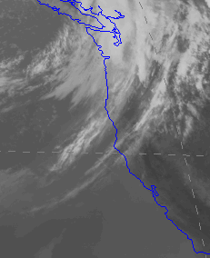
“Washing ashore” is the perfect description. Meanwhile, high up overhead, our neighborhood weather satellite captures the infrared image showing the bands of clouds filtering towards the coast.
If it cools down inland overnight, that means tommorrow will be a day to bail out of late afternoon work responsibilities and go swing a two-handed rod on some river somewhere. A true harbinger of fall passing through but the longer forecast shows triple digit temperatures returning later in the week – a typical August feint. But it will only get better from here.
